A hypercane is a hypothetical class of extreme hurricane that could form if ocean temperatures reached around 50 °C (122 °F), which is 12 °C (21°F) warmer than the warmest ocean temperature ever recorded.[1] Such an increase could be caused by a large asteroid or comet impact, a large supervolcanic eruption, or extensive global warming.[2] There is some speculation that a series of hypercanes resulting from an impact by a large asteroid or comet contributed to the demise of the dinosaurs. The hypothesis was created by Kerry Emanuel of MIT who also coined the term.[3][4][5]
Description[]
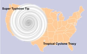
The relative sizes of Typhoon Tip, Cyclone Tracy, and the United States.
In order to form a hypercane, according to Emanuel's hypothetical model, the ocean temperature would have to be 48 °C (120 °F). A critical difference between a hypercane and present-day hurricanes is that a hypercane would extend into the upper stratosphere, whereas present-day hurricanes extend into only the lower stratosphere.[6]
Hypercanes would have wind speeds of over 800 km/h (500 mph), and would also have a central pressure of less than 70 kilopascals (21 inHg) (700 millibars), giving them an enormous lifespan.[4] For comparison, the largest and most intense storm on record was 1979's Typhoon Tip, with a wind speed of 305 kilometres per hour (190 mph) and central pressure of 87 kilopascals (26 inHg) (870 millibars). Such a storm would be eight times more powerful than the strongest storms yet recorded.[7]
The extreme conditions needed to create a hypercane could conceivably produce a system up to the size of North America, creating storm surges of 18 m (59 ft) and an eye nearly 300 km (190 mi) across. The waters could remain hot enough for weeks, allowing more hypercanes to be formed. A hypercane's clouds would reach 30 km (19 mi) into the stratosphere. Such an intense storm would also damage the Earth's ozone.[4] Water molecules in the stratosphere would react with ozone to accelerate decay into O2 and reduce absorption of ultraviolet light.
Mechanism[]
A hurricane functions as a Carnot heat engine powered by the temperature difference between the sea and the stratosphere. As air is drawn in towards the eye it acquires latent heat from evaporating sea-water, which is then released as sensible heat during the rise inside the eyewall and radiated away at the top of the storm system. The energy input is balanced by energy dissipation in a turbulent boundary layer close to the surface, which leads to an energy balance equilibrium.
However, in Emanuel's model, if the temperature difference between the sea and stratosphere is too large there is no solution to the equilibrium equation. As more air is drawn in, the released heat reduces the central pressure further. The lower the pressure the more heat is drawn in, leading to a runaway process. The actual limit to hypercane intensity depends on other energy dissipation factors that are uncertain: whether inflow ceases to be isothermal, whether shock waves would form in the outflow around the eye, or whether turbulent breakdown of the vortex happens."extinction" /Kerry A. Emanuel. The maximum intensity of hurricanes. Journal of the atmospheric sciences. Vol 45, no 7. pp. 1143-1155. 1988
See also[]
- ↑ "Temperature of Ocean Water". Windows to the Universe. University Corporation for Atmospheric Research. August 31, 2001. http://www.windows.ucar.edu/tour/link=/earth/Water/temp.html&edu=high. Retrieved July 24, 2008.
- ↑ Leahy, Stephen (September 16, 2005). "The Dawn of the Hypercane?". Inter Press Service. http://ipsnews.net/news.asp?idnews=30308. Retrieved July 24, 2008.
- ↑ Template:Cite journal
- ↑ 4.0 4.1 4.2 Emanuel, Kerry (September 16, 1996). "Limits on Hurricane Intensity". Center for Meteorology and Physical Oceanography, MIT. http://wind.mit.edu/~emanuel/holem/holem.html. Retrieved July 24, 2008.
- ↑ Template:Cite journal
- ↑ Template:Cite interview
- ↑ Template:Cite interview