| Category 3 typhoon (SSHS) | |
|---|---|

| |
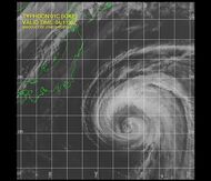
| Satellite image of Typhoon Halola at 2359Z on September 12, 2015 | |
| Formed | September 1, 2015 |
| Dissipated | September 20, 2015 |
| Highest winds | 10-minute sustained: 155 km/h (100 mph) 1-minute sustained: 205 km/h (125 mph) Gusts: 250 km/h (155 mph) |
| Lowest pressure | 940 hPa (mbar) |
| Fatalities | 0 confirmed, 0 missing |
| Damage | $0,000 (2015 USD) |
| Areas affected | None |
| Part of the 2015 Pacific typhoon season | |
Typhoon Halola, formerly Tropical Storm Halola/02C from the Central Pacific, was one of many storms that formed during the very active 2015 Pacific hurricane season.
Meteorological history[]

.jpg)
Map plotting the track and intensity of the storm according to the Saffir–Simpson hurricane wind scale
The origins of Halola can be traced all the way back to a Tropical Wave that was spawned in the Atlantic Ocean, near the Lesser Antilles on August 5th, 2015.
Conditions around the disturbance at the time originally favored some decent development, in fact, forecasters at the National Hurricane Center in Miami, FL were calling for "One Mean Hurricane" within a week, in which case, it would have been named Bill
The Disturbance grew more organized and eventually did develop a circulation center, but before the National Hurricane Center could start issuing Advisories on Would-Be Tropical Depression Three, the Cyclone went over Jamaica late on August 7th, the rough and mountainous terrain of Jamaica, nearly Killing it in the Process.
The Low survived the travel over Jamaica and crossed over Mexico later on, entering the eastern pacific area of responsibility on August 11th.
Upon Entering the Eastern Pacific, Former Invest 96L became Invest 99E, and it was coming in from behind Tropical Storm Kevin. For a Weak Tropical Storm, Kevin's rather Modest outflow sheared the Growing Invest

Halola as Invest 99E, in close proximity to Tropical Storm Kevin
Despite the line of storms that had gone across the Eastern Pacific Ocean, waters remained warm, and upper level conditions were great, and soon, Kevin weakened and dissipated, the precursor to Halola absorbing the rest of Kevin as it accelerated westward.
Over the next Two Weeks, Pre-Halola had to avoid larger storms, such as Linda, Marty and Nora, whilst staying a relatively safe distance away from all.
It finally crossed 140W and into the Central Pacific on August 29th, and the Central Pacific Hurricane Center in Hawaii forecasted Development into at least a Tropical Storm by September 1st/2nd.
Convection quickly increased and organized during the day on August 31st, and the low pressure center of later-halola, which had Survived nearly a Whole Month avoiding several Tropical Cyclone after crossing over Mexico, became a closed center of circulation.
Thus, it finally became Tropical Depression Two-C early on September 1st.

Halola as a Strong Tropical Storm Early on September 4th
Perfectly Favorable conditions allowed the Depression to become Tropical Storm Halola on September 2nd, the Second Named storm for the Central Pacific.
The Central Pacific Hurricane Center forecasted a peak of 80 mph (130 km/h) by September 7th, followed by weakening back to Tropical Storm Status.
As soon as Halola crossed the 180 Meridian and into the Western Pacific, it began to intensify a little more rapidly, reaching Typhoon status mid-day on September 6th, sooner than previously forecasted.


Halola as a Strong Category-2 Late on September 10th
Taking advantage of excellent conditions, Halola continued to slowly intensify, soon reaching it's peak of 125 mph (205 km/h) on September 12th


A Colored IR Image of Typhoon Halola taken at 0152Z on September 13th while at Peak intensity
After spending 30 hours at peak intensity, Cooler Waters, stronger shear and dry air stated to kill the Cyclone, it weaken to Category-2 by September 15th, and spent until late on September 18th as a Category-1
Conditions became Highly Unfavorable and this Lead to Halola's Demise on September 20th, after nearly 3 weeks of being active.
Preparations and impact[]

_2006-09-04_11-30.jpg)
Halola as a Strong Category-1 at 1942Z on September 17th
Ahead of the Storm, Guam underwent Intense Preparations, fearing Halola would be a Catastrophic Storm.
At the same time Halola strengthened to it's peak intensity, it also moved a little more north, Guam being narrowly avoided in the process.
During Halola's Weakening and Dissipation, Locals in Guam considered Halola "A great example of preparing if a more serious storm were to approach or hit".
Aftermath[]
Halola had little known affect on land, other than increased surf and rip currents, but nothing note-worthy occurred.
Retirement[]
Since Halola never caused any significant effects on land, the name was not retired in the spring of 2016.